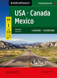
USA, Canada and Mexico Road Atlas
Dubbelkollade priser
Jämför 2 butiker
- Adlibris, 350 kr, frakt enligt butiken. Till butik (öppnas i ny flik)
Slut i lagerFrakt: se butikenDubbelkollad 27 okt. 09:10
350 kr
- Buyersclub, 359 kr, frakt enligt butiken. Till butik (öppnas i ny flik)
Slut i lagerFrakt: se butikenDubbelkollad 30 okt. 05:33
359 kr


Priser från butikernas flöden kan ha ändrats: det är priset hos butiken som gäller, så kontrollera det innan du handlar.
Prishistorik
Köp nu eller vänta?
- Lägst
- 350 kr
- Snitt
- 350 kr
- Högst
- 359 kr
| 2026-09-15 | 350 kr · Lägst hos Adlibris |
|---|---|
| 2026-10-06 | 359 kr · Lägst hos Buyersclub |
| 2026-10-08 | 350 kr · Lägst hos Adlibris |
| 2026-10-27 | Ingen butik hade produkten i lager |
Om produkten
USA, Canada and Mexico Road Atlas
Läs merLäs mindre
The USA - Canada - Mexico Road Atlas 1:400,000 - 1:16,000,000 is the ideal companion for anyone traveling in North America by car or camper. It's ideal for planning and also proves to be an indispensable orientation aid during the trip. The map scale varies by state. Mexico is included as an overview map. The atlas also offers detailed maps of over 50 North American cities, as well as a map showing distances and travel times between hundreds of cities. Information on the USA - Canada - Mexico road atlas USA - Canada - Mexico 1:400,000 - 1:16 Mio. spiral binding National Parks Tourist information 50 city maps 184 pages, format 20.3 x 27.5 cm Spiral binding: The USA - Canada - Mexico road atlas is particularly convenient to use, thanks to its spiral binding, which allows it to be easily opened. This way, the desired page always remains open, even while driving. City center maps The 50 included city maps make it easy to find your way around the cities.